

1.4.1. Selected Tools for Integrated Land Use Planning
The following table lists 50 selected tools from the Land Resources Planning Toolbox (LRPT) that are especially relevant for integrated land use planning. The acronyms in the table allow direct access to these tools within the LRPT. The letter and numerical codes are the same ones used in Figure 3 .
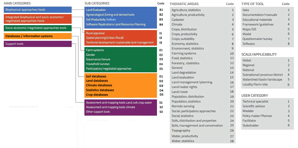
| Tool and acronym | Category & sub-category | Thematic area | Type of Tool | Scale/ Applicability | User category |
| Africa Soil Information Service (AFSIS) | D1 | 24 | 1, 5 | 3-5 | 1, 2 |
| GCM Downscaled Data (CCAFS-CLIMATE) | S2 | 4 | 1, 5 | 1-5 | 1, 3 |
| Global Land Cover Data products (CCI_LC) | D2 | 21 | 1 | 1-5 | 1, 2 |
| Community Mapping (COMAP) | E | 22 | 7 | 6 | 5, 6 |
| Global Dynamic Land Cover product (COPERNICUS_LC) | D2 | 21 | 1 | 1-5 | 1, 2 |
| Crop Simulation Model (CROPSYST) | B1 | 6 | 6 | 6 | 1-3 |
| Dimitra Clubs (DIMITRA) | E2 | 22 | 3, 7 | 6 | 6 |
| Driver-Pressure-State-Impact-Response Framework (DPSIR) | I3 | 14, 16 | 4 | 3, 4 | 2, 4 |
| Decision-Support System for Agro-technology Transfer (DSSAT) | S1 | 2, 6 | 8 | 6 | 3 |
| Evaluation of Land Management Options (ELMO) | E5 | 16 | 4, 7 | 6 | 5, 6 |
| European Soil Data Centre (ESDAC) | D1 | 24 | 5 | 2-4 | 1 |
| Ex-Ante Carbon Balance Tool (EX-ACT) | S2 | 4 | 8 | 4, 5 | 1, 2 |
| Global Food and Agriculture Statistics of FAO (FAOSTAT) | D4 | 1, 11 | 1 | 3 | 1, 4 |
| Framework for Land Evaluation (FLE) | B1 | 15 | 4 | 3-5 | 1, 2, 4 |
| Guidelines for Integrated Land Resource Management Planning (FUTURE_LAND) | I3 | 16 | 4 | 3-6 | 1, 2, 4 |
| Global Agro-Ecological Zones (GAEZ) | B2 | 4, 7, 18, 24 | 1 | 1-4 | 1, 2 |
| Global Forest Watch (GFW) | D2 | 18, 21 | 5 | 1-3 | 1, 2 |
| Gender and Land Rights Database (GLRD) | D4 | 17, 23 | 1 | 3 | 4 |
| Toolkit: Green Negotiated Territorial Development (GreeNTD) | E5 | 22 | 2 | 5, 6 | 2, 4, 5 |
| Guidelines for Land Use Planning (Guide_LUP) | I3 | 16 | 4 | 3-6 | 4 |
| Harmonized World Soil Database (HWSD) | D1 | 24 | 1 | 1-4 | 1 |
| Improving Gender Equality in Territorial Issues (IGETI) | E2 | 22 | 4 | 6 | 5, 6 |
| Participatory mapping of customary forest use (ILC_ID) | E5 | 17, 22 | 3 | 5, 6 | 4 |
| Participatory Mapping for Empowerment (ILC_PM) | I3 | 3, 17, 22 | 3, 5 | 5, 6 | 2, 5, 6 |
| ISRIC Soil Data Hub (ISRIC_SOILS) | D1 | 24 | 1, 5 | 1 | 1 |
| Assessment of land degradation at local level (LADA_LOC) | I3 | 14, 25 | 2 | 6/1 | 1, 2, 6 |
| Evaluation of land degradation and conservation (LADA-WOCAT QM) | I3 | 14, 25 | 2 | 3,4 | 1, 2, 6 |
| Land Evaluation for Forestry (LE_FOR) | B1 | 15 | 4 | 3-5 | 1, 2 |
| Land Evaluation for Extensive Grazing (LE_GRAZ) | B1 | 15 | 4 | 3-5 | 1, 2 |
| Land Evaluation for Irrigated Agriculture (LE_IRR) | B1 | 15 | 4 | 3-5 | 1, 2 |
| Land Evaluation for Rainfed Agriculture (LE_RAIN) | B1 | 15 | 4 | 3-5 | 1, 2 |
| Land Evaluation and Farming Systems Analysis (LEFSA) | I3 | 10, 15, 16 | 4 | 3-5 | 1, 2 |
| Logical Framework Analysis (LFA) | S3 | 13 | 4 | 1-6 | 4 |
| Livelihood Zones (L-ZONES) | I1 | 10 | 1, 5 | 3-4 | 1, 2, 4 |
| Mapping Climate Change Vulnerability and Impact Scenarios (MAP_CCVIS) | I2 | 4, 16 | 3, 4 | 4 | 4 |
| Micro-regional planning (MRP) | I2 | 16 | 4 | 5 | 4 |
| Negotiated territorial development (NTD) | I3 | 16, 22 | 3, 4 | 3, 4 | 4-6 |
| Participatory Land Use Development in Bosnia and Herzegovina (PLUD) | I3 | 16, 22 | 3 | 4, 5 | 4-6 |
| Participatory Mapping of Ecosystem Services (PMAP_ECOS) | I1 | 10, 21, 22 | 4, 7 | 5 | 2, 5, 6 |
| Participatory and Negotiated Territorial Development (PNTD) | E5 | 22 | 4 | 4-6 | 1, 5, 6 |
| Participatory territorial planning in the Philippines (PTP_PHI) | I3 | 16, 22 | 2 | 5, 6 | 5, 6 |
| Evaluation of (sub)national land degradation and conservation (QM) | I3 | 14, 25 | 2 | 3, 4 | 1, 2, 6 |
| Rapid Rural Appraisal (RRA) | I1 | 10 | 4 | 5, 6 | 1, 5 |
| Socio-Economic and Gender Analysis (SEAGA) | I1 | 22 | 2, 3 | 6 | 5, 6 |
| Spatial Planning and Monitoring of Landscape Interventions (SPMLI) | I3 | 16 | 2, 4 | 5, 6 | 1, 5, 6 |
| Shuttle Radar Topographic Mission Digital Elevation Model (SRTM) | D2 | 26 | 5 | 5, 6 | 1, 3 |
| Visual Soil Assessment Field Guides (VSA) | B1 | 14, 15, 24 | 2 | 6 | 1, 2, 6 |
| World Food Studies Simulation Model (WOFOST) | B1 | 6 | 6 | 5, 6 | 1, 3 |
| WorldClim – Global Climate Data (WORLDCLIM) | D3 | 4 | 5 | 1-5 | 1, 3 |
| High Resolution Population Distribution Maps (WORLDPOP) | S3 | 19 | 5 | 1-4 | 1, 3 |