
Implementing Integrated Land Use Planning: A step-by-step guide for rural areas
INTRODUCTORY GUIDE: CHAPTER 1. NATURE AND SCOPE
1.6. Emerging issues in land use planning
This section highlights key issues that require greater attention in land use planning. These topics are of global significance, shaping both the content and approaches of land use planning. As a result, land use planning is becoming increasingly multidimensional and complex.
1.6.1. Climate change
Climate change has evolved from a scientific concern in the early 1970s to a global crisis. The recognition of its serious threat to humanity is largely due to the work of the Intergovernmental Panel on Climate Change (IPCC), established in 1988.
While early debates struggled to distinguish human-induced climate change from natural variability, the evidence is now irrefutable: global warming is driven by human-induced CO2 emissions. These changes are already manifesting in weather patterns and appear to be accelerating.
At the global level, the consequences of climate change are predominantly negative:
• Rising sea levels due to ice-cap melting, increasing the risk of coastal flooding and storms.
• Accelerated glacier and snowmelt, reducing water availability for downstream agriculture and winter tourism.
• More frequent and intense heatwaves, leading to higher mortality rates among vulnerable populations and increased wildfires.
• More droughts and unpredictable growing seasons, heightening the risk of crop failures.
• More intense rainfall events, exacerbating soil erosion, sedimentation, and landslides.
• Increased spread of pests and diseases, affecting both human and agricultural health.
• Loss of biodiversity, threatening ecosystems and food chains.
• Ocean acidification, endangering fish populations and marine life.
• Greater socio-economic vulnerability, increasing risks of civil unrest and mass migration.
However, some regions may experience positive effects:
New agricultural opportunities in areas that were previously too cold for crop production or livestock farming.
Expansion of forests and vegetation, potentially absorbing excess atmospheric CO2 and mitigating global warming.
Increased rainfall in some arid regions, potentially enhancing agricultural productivity.
While the specific impacts will vary by location, no nation will remain unaffected.
Given the increasing likelihood of extreme climate events and their implications for food security, climate change must be a central consideration in all levels of land use planning. However, there is growing recognition that much more needs to be done to integrate climate change into planning processes. This is particularly concerning given that current models provide fairly reliable projections of future impacts.
Fundamental tools for generating these projections include Global Circulation Models (GCMs), spatial and temporal downscaling techniques, and impact models. One notable example of an integrated application of these tools is the Global Agro-Ecological Zones (GAEZ) methodology (Fischer et al., 2021). This model predicts yield and production levels for major crops under different input and management scenarios (e.g., rainfed systems, various irrigation types). By matching land qualities with the specific energy, moisture, and nutrient requirements of crops, GAEZ can inform land use planning at national and subnational levels.
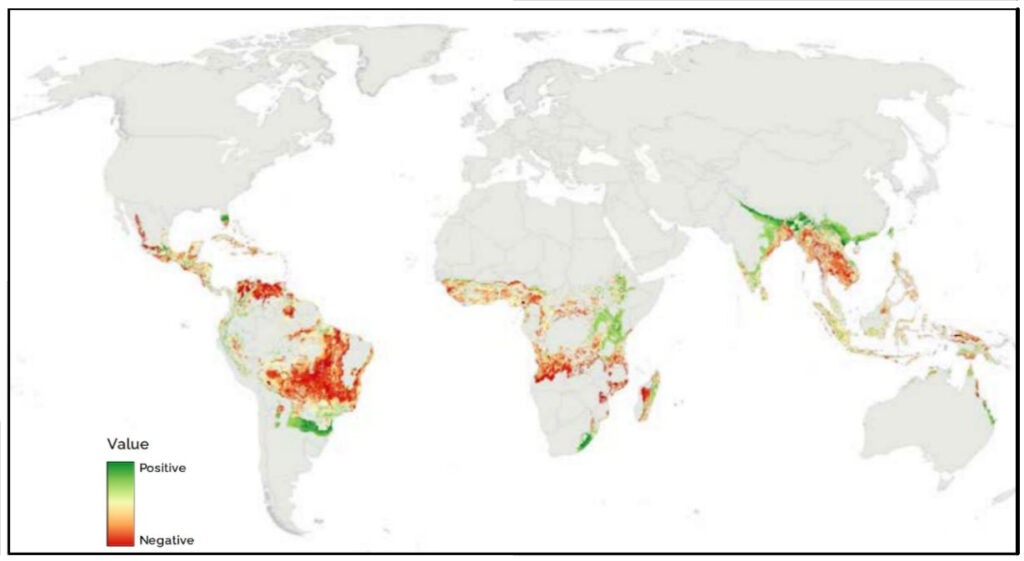
Such insights help decision-makers explore shifts in crop choices, land use adjustments, and changes in input and management levels. Box 2 illustrates projected global changes in coffee suitability, while Box 3 presents a global yield gap analysis that can be replicated for future conditions.
Box 2. Land suitability for projected future climatic conditions
GAEZ4 utilizes IPCC AR5 climate model outputs for four Representative Concentration Pathways (RCPs) to assess a range of possible future climate scenarios and their impact on crop potential. These assessments cover three time periods: the 2020s (2011–2040), the 2050s (2041–2070), and the 2080s (2070–2099).
These projected climatic datasets enable evaluations of how climate change will affect the suitability of individual Land Use Types (LUTs) using the same methodologies applied to current climatic conditions. Mapping these projected changes is valuable for land use planning, as it allows for proactive adaptation to anticipated shifts in temperature and moisture conditions. An example is provided in Figure 7. The map indicates that coffee cultivation will respond differently across various regions. Coffee production in West Africa and parts of Southeast Asia is projected to decline significantly, whereas in Ethiopia, Kenya, and the highlands of Asia, higher temperatures may enhance coffee suitability. These insights should be considered when developing land use plans.
Box 3. Land productivity assessment
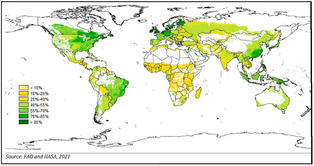
GAEZ provides estimates of current land productivity through spatialized yield gaps—the difference between attainable and actual yields. Actual yields are derived from national statistical data, which are typically aggregated at large spatial scales, such as entire countries or first-level subnational administrative units (provinces, regions, etc.). To assess yield gaps at the grid cell level, GAEZ employs a spatial downscaling method based on a statistical iterative optimization process. This method assigns plausible actual yield levels to grid cells while ensuring consistency with local data obtained from remote sensing, aggregate agricultural statistics, and other available sources. An example of a yield gap analysis is provided in Figure 8.
The map reveals that yield potential remains largely untapped across much of Africa, India, and Central Europe. Various factors may contribute to these gaps, but such analyses help pinpoint underperforming areas for further investigation.
The results of this and similar analyses facilitate the identification of areas of concern and agro-environmental hotspots under climate change. These insights can inform climate change adaptation and mitigation measures at regional and subnational levels. A thorough understanding of agro-environmental hotspots supports better decision-making regarding climate policies, planning, institutional frameworks, and the implementation of targeted adaptation and mitigation strategies.
A key approach to managing existing agro-environmental hotspots and preventing new ones from emerging under climate change is the sustainable management of landscapes, soil, and water resources. Integrated land use planning must incorporate strategies to enhance the resilience of smallholders and broader populations to climate risks. This may include adapting agronomic practices, diversifying livelihoods, implementing social protection measures, and improving access to weather and climate information services.