
Implementing Integrated Land Use Planning: A step-by-step guide for rural areas
PRACTITIONER’S GUIDE: STEP 1
PART 1
PRACTITIONER’S GUIDE
INTRODUCTION
This chapter outlines the tasks involved in a land use planning project, following the nine-step approach introduced in the previous chapter. Each step is structured to address the following key questions:
1. Who is responsible for implementing this step?
2. What are the key issues to consider?
3. What main activities need to be undertaken?
4. What deliverables serve as evidence of accomplishment?
5. Which tools can support this step?
Each step concludes with a Checklist summarizing the key points.
As noted in Chapter 2 , these steps are conceptually scale-independent, meaning they can be applied at different planning levels (national, district, local). However, the implementation approach may vary accordingly. Where relevant, discussions on a particular step are divided by planning level.
To further illustrate key concepts, this Guide includes examples from case studies and references to useful tools.
It also provides links to thematic tools and approaches, which – identified by their acronyms -correspond to those listed in the Land Resources Planning Toolbox. Additional details on how specific tools apply to different planning steps are provided in the relevant Step chapter.
Step 1
INITIATE THE LAND USE PLANNING PROCESS
1.1. INITIATORS AND RESPONSIBILITIES
Initiating a land use planning process is typically a political decision, triggered by the recognition of a land-related problem that requires resolution. Awareness of such issues may arise from scientific studies conducted by national technical agencies, calls for action from international bodies, or public concern. Political pressure to act can originate from both top-down (e.g., international obligations) and bottom-up (e.g., local communities) sources.
For example, international agreements signed by the country may include commitments to achieve land degradation neutrality or to reduce CO₂ emissions by specific targets and deadlines. Alternatively, land users, NGOs, or extension workers may raise concerns about issues such as overstocking or increasing soil erosion. In some cases, natural disasters—such as flooding, landslides, typhoons, or wildfires—may prompt public demand or direct action by policymakers to initiate land use planning.
Depending on the scale of the problem, national or sub-national policymakers and decision-makers are prompted to fulfill their mandated role as initiators of the planning process. Since addressing land issues often requires specialized expertise, decision-makers typically delegate the task to an ad hoc coordinating entity responsible for developing the planning framework and guiding further action.
The nature of this coordinating entity depends on the planning level:
• At the national or sub-national level, it is usually a planning unit within a government agency.
• At the local level, it could be a town or village council committee, a local government service, or a committed NGO.
Land use planning units are often housed within ministries such as Agriculture, Forestry, or Environment, where they typically manage sectoral interventions. In some countries, there exists an integrated land use planning unit with a mandate to address cross-sectoral land use issues, including social and legal considerations.
Regardless of the institutional setup, it is crucial for a country to have a designated coordinating body for land use planning—and for this body to be publicly recognized in that role. Throughout this document, this body is referred to as the Coordinating Unit.
1.2. KEY QUESTIONS
Once the Initiator(s) have flagged a land use problem, the Coordinating Unit begins a preliminary investigation to address several key questions:
What are the specific problems to be addressed?
To tackle the problem effectively, it must be clearly understood and defined by the Coordinating Unit in a way that enables an ad-hoc Task Force (Step 3) to develop the required planning phases, conduct studies, and implement actions.
Often, multiple interrelated land use problems are present rather than a single issue. In simpler cases, challenges can be addressed through changes in land and water management, including technical interventions, input and management adjustments, and resource or credit provision.
More complex issues may require fundamental changes in land use type, ownership, or access. If expropriation is considered, it should be justified in the public interest and based on fair compensation.
Such complexities require analysis by a multidisciplinary team (Step 5). However, even in Step 1, the Coordinating Unit should develop a sound understanding of the causes and effects behind the land use issue to identify potential sustainable solutions.
The DPSIR Framework offers a useful method for organizing analysis around land use challenges (see Box 5).
Box 5. The DPSIR Framework: a tool for understanding causes and impacts of land use change
The DPSIR (Driver–Pressure–State–Impact–Response) Framework helps to understand the logical sequence by which driving forces (D) lead to pressures (P) that influence the current state (S) of the land and its impacts (I) on ecosystems, while also encouraging reflection on possible curative responses (R).
Driving forces—such as economic sectors, human activities, or population growth—can lead to a build-up of pressures, including emissions, pollution, and waste. These pressures contribute to unstable or undesirable states of the environment, such as physical, chemical, biological, or water resource degradation. In turn, these states may impact the health of ecosystem services, including water quality, climate regulation, soil productivity, and public health. When impacts become serious, they may trigger political responses such as new legislation, the setting of priority targets, or the initiation of funded problem-solving projects.
Even in its simplest representation (Figure 11), it is clear that the DPSIR Framework is structured around feedback loops, where different types of responses can directly influence the drivers, pressures, state, or impacts—potentially requiring further responses over time.
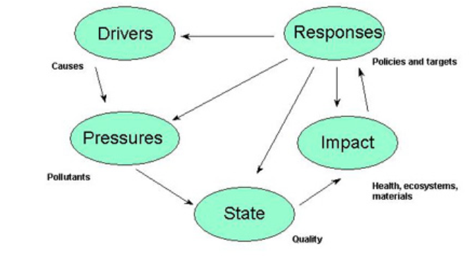
The framework emphasizes that the nature of the response to a given problem—including inaction, which is also considered a response—can influence the drivers, either increase or reduce the pressures, alter the state of the environment, and create its own positive or negative impacts.
The main advantage of the DPSIR Framework is that, even at the initial planning stage, it enables initiators, coordinating units, and major stakeholders to think in terms of cause–effect relationships, and to evaluate how different responses could affect outcomes positively or negatively. Moreover, the framework is applicable at all levels, from national to local.
However, for any specific land resource issue, describing the causal chain from driving forces to impacts—and projecting how different responses may influence the outcome—is a complex task. It requires specifying interactions in more detail and is best assigned to the Land Use Planning Task Force during Step 4 and Step 5.
An example of how to apply the DPSIR Framework to a concrete land resource problem is shown in Figure 12. This example highlights the potential role of integrated land use planning in responding to drivers, pressures, and impacts of land use change.
Annex 1 provides a comprehensive list of examples of drivers, pressures, states, impacts, and responses related to land use.
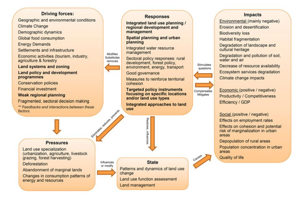
(Metternicht, 2018)
What are the short-term and long-term objectives of the planning exercise?
To ensure a successful response, clear objectives must be formulated early by the Coordinating Unit to guide the work of the Task Force. The clearer the objectives, the better the Task Force can develop detailed plan components.
A key requirement in setting objectives is to define a realistic outcome for the planning exercise. This means acknowledging resource and time constraints, and aiming for quantifiable improvements, not unattainable ideals.
What are the boundaries of the area to be addressed? What are its biophysical and social characteristics?
The planning area should be mapped and basic information compiled, such as size, population centers, infrastructure, topography, land use, and livelihood patterns. Preliminary tenure data (public, private, communal lands) may also be collected if available.
At this stage, detailed accuracy is not required. Mapping and characterization will be thoroughly revisited during Step 4 and Step 5 by technical teams and stakeholders.
Who are the people affected by the planning?
In principle, all residents in the planning area will be affected. It is helpful to distinguish between:
• Direct stakeholders, such as farmers, pastoralists, forest product harvesters, and private enterprises.
• Indirect stakeholders, affected by external effects, such as downstream or downslope communities.
Examples of such effects include salt leaching from irrigation affecting downstream areas, livestock displacement due to overstocking restrictions, or nutrient loss downstream when erosion is controlled upstream.
Indirect stakeholders also include entities concerned with long-term sustainable land use, such as government agencies, NGOs, and land user associations (further discussed in Step 2).
How will the land use planning project be conducted?
This concerns pre-planning logistics, which require consultation among the Initiators, Coordinating Unit, and major stakeholders. Agreements should cover:
• Command structure
• Team composition and expertise
• Objectives and activities
• Reporting procedures
• Time frame
• Indicative budget
These arrangements are formalized in a memorandum-type document to be handed over to the Land Use Planning Task Force, established in Step 3.