
Implementing Integrated Land Use Planning: A step-by-step guide for rural areas
PRACTITIONER’S GUIDE: STEP 6
PART 1
Step 6
NEGOTIATE SUITABLE AND ACCEPTABLE LAND USE OPTIONS
6.1. THE NEGOTIATION PROCESS
The output of Step 5 is a selection of land use and management options for different land mapping units. These options were identified as feasible based on multidisciplinary studies covering land suitability, economic viability, environmental and social acceptability, and compatibility with existing land use legislation.
In addition, Step 5 produced a preliminary evaluation in the form of a goals achievement matrix (GAM), which assessed the performance of each land use alternative against the criteria set by the Task Force.
The objective of the current step is to obtain agreement from the various stakeholders on which options to implement on specific tracts of land. This agreement leads to what is referred to in various studies (e.g. Biancalani et al., 2004; FAO, 2012a; Tarrason et al., 2017) as a territorial pact.
To reach such an agreement, negotiations are usually required in territorial development initiatives. This need arises from (1) the diversity of social and cultural backgrounds, (2) differing and sometimes conflicting stakeholder interests, and (3) existing power asymmetries in the management of land, forests, marine areas, coasts, river basins, and their associated goods and services (Tarrason et al., 2017).
In contexts where such fault lines exist, the introduction of new land development plans can disrupt the existing balance, often leading to new conflicts or the escalation of latent tensions. It is the responsibility of the Task Force to organize a forum where negotiations can take place and to provide mediation aimed at reaching consensus and resolving potential conflicts. This forum represents the primary opportunity for all stakeholders to express their views. Within this setting, every effort must be made to address disputes arising from conflicting objectives. In cases where disagreements cannot be resolved, a legal mechanism should be available for recourse to a land arbitration body or the courts. However, legal arbitration typically results in delays in implementing the land use plan—or parts of it—and should therefore be considered a last resort (FAO/UNEP, 1999).
6.1.1. Planning for successful negotiations
There is no universal blueprint for negotiation processes, as each must be tailored to its specific context and involve all relevant actors, including social groups, NGOs, the private sector, and government institutions. However, there are some fundamental principles to follow:
• Anticipate potential conflict
• Focus on interests rather than positions
6.1.1.1. Plan for managing potential conflicts
Conflicts over land are common and occur at all levels. According to Knight (2018), communities may face three main types of land conflict:
- Conflicts within a community — These may arise between members of a household, between different families, or among sub-groups within a community. For instance, local elites may attempt to unjustly claim communal land as their private property.
- Conflicts between neighboring communities — Such disputes are often related to unclear or contested boundaries.
- Conflicts between a community and external actors — These may involve individuals such as investors or government officials. For example, conflict can occur when the government sells or leases community land to an investor without community consultation.
Wehrmann (2008) proposed a broader classification system for land conflicts, identifying four major categories:
• Conflicts occurring on all types of property
• Specific conflicts over private property
• Specific conflicts over common or collective property
• Specific conflicts over state property
Within these categories, Wehrmann further distinguishes 35 different conflict types and more than 50 sub-types. Understanding the precise nature of a land conflict is essential for finding an effective resolution.
Rather than waiting to respond after conflicts arise, communities should take a proactive approach by identifying potential issues and preparing conflict management plans in advance. Knight (2018) suggests two simple yet effective activities for communities:
• Identify conflict warning signs
• Prepare a list of individuals, organizations, and strategies that could assist in resolving conflicts
Tarrason et al. (2017) describe several tools for conflict analysis (Box 24). Ideally, some of these tools were already used to analyze stakeholder characteristics during Step 4. If not, they can be reintroduced and applied in this Step as part of the planning for the negotiation process.
Box 24. Tools for conflict analysis (source: Tarrason et al., 2017)
- Tool 1: 4R analysis
This tool examines the rights, responsibilities, and revenues (benefits) of stakeholders, along with the relationships among or within stakeholder groups. Understanding differences in these four dimensions is often crucial to identifying the roots of conflict. Inequities among stakeholders in terms of rights, responsibilities, and benefits frequently reflect power imbalances, which in turn shape inter-group relationships. - Tool 2: Power/interest matrix
This matrix is used to assess the power and interests of stakeholders regarding specific land or natural resource issues. It can help identify hidden or invisible stakeholders who may be central to the conflict but are not immediately apparent. - Tool 3: Governance analysis
This tool explores the characteristics and relationships of key stakeholders and institutions, analyzing their power, interests, and legitimacy in relation to access and use of natural resources. - Tool 4: Conflict timeline
A conflict timeline helps stakeholders review the history of a conflict, clarifying the sequence of events that led to the current situation. It records what each party has done, when, and how, demonstrating that mediators value stakeholder perspectives and aiding in structuring discussions and managing complex information. - Tool 5: Conflict map of resources
This tool identifies the geographical locations where land or resource conflicts exist or may arise in the future and highlights the primary issues involved. Mapping provides insight into the spatial dimension and geographic boundaries of conflicts. Engaging stakeholder groups in the mapping process helps structure discussion and encourages active participation in conflict analysis. This tool builds on the mapping work conducted in Steps 4 and 5. - Tool 6: Scenario development
Scenario development involves creating plausible and contrasting narratives that describe potential future developments of key conflicts. These scenarios are simplified representations of alternative hypothetical futures, based on an analysis of key driving forces and their interrelationships.
Some of these tools (Tools 1–3) focus on the characterization and interrelationships of stakeholders and may provide insights into the structural causes of land conflicts. Others (Tools 4–6) address the conflicts themselves by analyzing stakeholder histories and geographical context. For further details on each of these tools, refer to Tarrason et al. (2017).
6.1.1.2. Focus on interests rather than positions
In negotiations, it is common for stakeholders to adopt maximalist positions at the outset. To navigate this, it is essential that opposing parties—assisted, if necessary, by a neutral mediator (see below)—make a concerted effort to look beyond stated positions and understand the underlying interests driving each side.
Interest-based negotiation shifts the focus from competing over rigid positions to exploring and addressing shared and divergent interests. A key task for the mediator is to help stakeholders distinguish between:
Positions – what parties publicly claim they want in the conflict
Interests – the actual motivations behind their positions, i.e., what they truly want
Needs – fundamental requirements that must be met, often non-negotiable
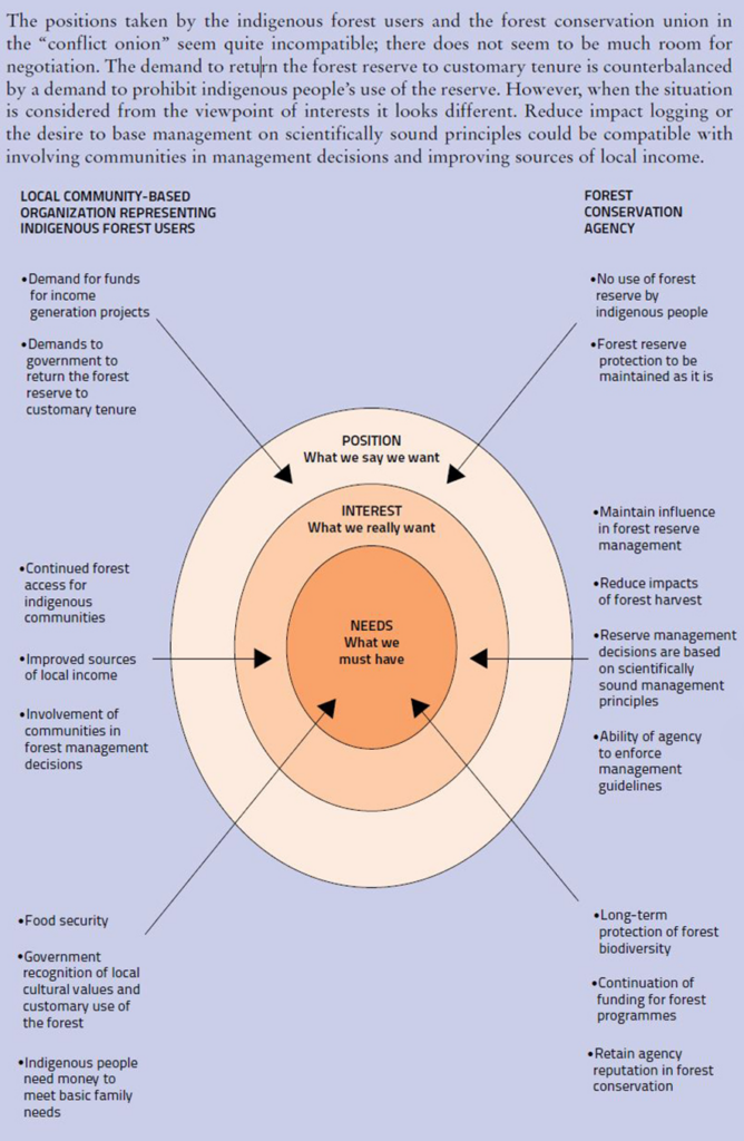
A valuable tool for facilitating this process is the conflict layer model (CLM)—also known as the conflict onion—as described by Tarrason et al. (2017). The CLM helps stakeholders analyze their positions, interests, and needs, offering a deeper understanding of what drives the conflict from all perspectives.
The model is visualized as concentric circles:
• The outer layer represents public positions—what stakeholders say and do.
• The middle layer reflects interests—what stakeholders aim to achieve.
• The core illustrates needs—the most basic motivations that stakeholders seek to fulfill. While interests are often negotiable, needs typically are not.
An example of applying the CLM to analyze these layers—focusing on indigenous forest users and a government forest conservation agency—is presented in Figure 30.
(source: Tarrason et al., 2017)