
Implementing Integrated Land Use Planning: A step-by-step guide for rural areas
PRACTITIONER’S GUIDE: STEP 5
PART 8
5.4. DELIVERABLES
Step 5 requires the preparation of substantive technical reports covering the key thematic areas of investigation: biophysical land suitability, economic suitability, environmental and social impacts, and legal analysis. In addition, these themes must be integrated into a comprehensive report that provides recommendations for development options which are biophysically optimal, economically viable, and minimize adverse environmental and social impacts.
The time and effort required to properly present the results of a land use planning study are often underestimated. Insufficient resources are commonly allocated to this crucial stage, which can undermine the effectiveness of the entire planning process. If a report is not clearly written or well-structured, it may compromise the credibility of the conclusions and recommendations in the eyes of stakeholders and discourage the adoption of the findings.
Presentation of study results is second only to the initial planning phase in importance. Therefore, it is essential to allocate adequate time and resources—from the outset—for the production of high-quality maps and reports (Dent and Young, 1981).
Box 23 outlines general guidelines for producing effective technical reports.
Box 23. General guidelines on presentation of results in reports (adapted from Dent and Young, 1981)
The fundamental aims of a technical report are:
• To inform the intended users about the content of the report
• To highlight how this information is relevant to the users
• To guide each user group to the information it needs and help it understand the content
To achieve these aims, target user groups must be identified, and the report should be structured so that each group can easily locate and understand the sections relevant to them. The diverse range of potential users—such as farmers, senior government officials, financiers, and various technical specialists—poses a challenge, as each group requires content and language suited to their needs.
Maintaining readability without losing essential information can be achieved by:
• Focusing on (1) a clear statement of the problem, and (2) a summary of results, conclusions, and recommendations
• Placing most of the technical content—written in appropriate discipline-specific jargon—in one or more technical appendices.
Adopting this approach leads to four main sections:
1. Summary
2. Main text
3. Technical appendices
4. Maps
In large projects, these sections may be published as separate volumes; otherwise, they can be organized within a single volume.
Note: The executive summary is a critical part of the report. It must provide a complete overview for all readers, be comprehensive and self-contained, and be written in plain language, avoiding technical jargon. Readers should not need to refer to the main text to understand it.
The next sections further discuss report contents and structures for the main themes.
5.4.1. Land suitability reports
Both physical and economic land evaluation aim to maximize benefits from the perspectives of sustainable land use and the land users. If both types of evaluation are conducted, they can be integrated into a single report.
A general report outline for a land suitability study—covering an area with potential for various land uses or management systems and assuming the inclusion of an economic land evaluation—is provided in Annex 3, Box 28. Such a study may be undertaken by a national agency as part of a systematic country-wide assessment, or by a private company in the context of a specific land development project.
5.4.2. Impact assessment reports
Environmental and social impacts are often assessed together as part of the same study package. This is logical, as environmental impacts—which are almost inevitable in new land developments—also have social consequences.
Preparing a joint impact report helps to clarify these cause-effect linkages.
The recommended framework for an environmental impact assessment (EIA) report (see Fig. 26) provides a solid basis for incorporating sections on social impact assessment (SIA). While EIA focuses particularly on threatened flora and fauna, the social sections of an EIA/SIA report must give special attention to vulnerable population groups, such as the poor, elderly, unemployed, women, and members of minority or marginalized groups.
Given the complex and varied issues addressed in SIA—especially when integrated within an EIA—no detailed standard report layout can be prescribed. However, Annex 3, Box 29 provides a broad outline of the topics to be included (note the similarities with the report outline in Box 28).
5.4.3. Identification of optimal development options
Step 5 focuses on the multidisciplinary analyses required to anticipate the benefits and costs of planned land use interventions. The goal is to identify an optimal outcome that maximizes the land’s biophysical and economic potential while minimizing negative environmental and social impacts.
A key challenge in choosing the best option is that it is rarely possible to achieve maximum benefits in all areas simultaneously. For example, using land according to its highest biophysical potential, while being sustainable and even environmentally friendly, does not necessarily result in the greatest economic or social benefits. Trade-offs are often unavoidable. Therefore, decisions must be made based on selected criteria and the relative importance assigned to each. These choices must also align with existing land use policies and regulations, and they will form part of the development options to be negotiated by stakeholders in Step 6.
To better understand the implications of the identified development options, it can be useful to present them in a Goals Achievement Matrix (GAM). An example from Dent and Young (1981), reproduced in FAO (1993), illustrates this approach (see Fig. 15).
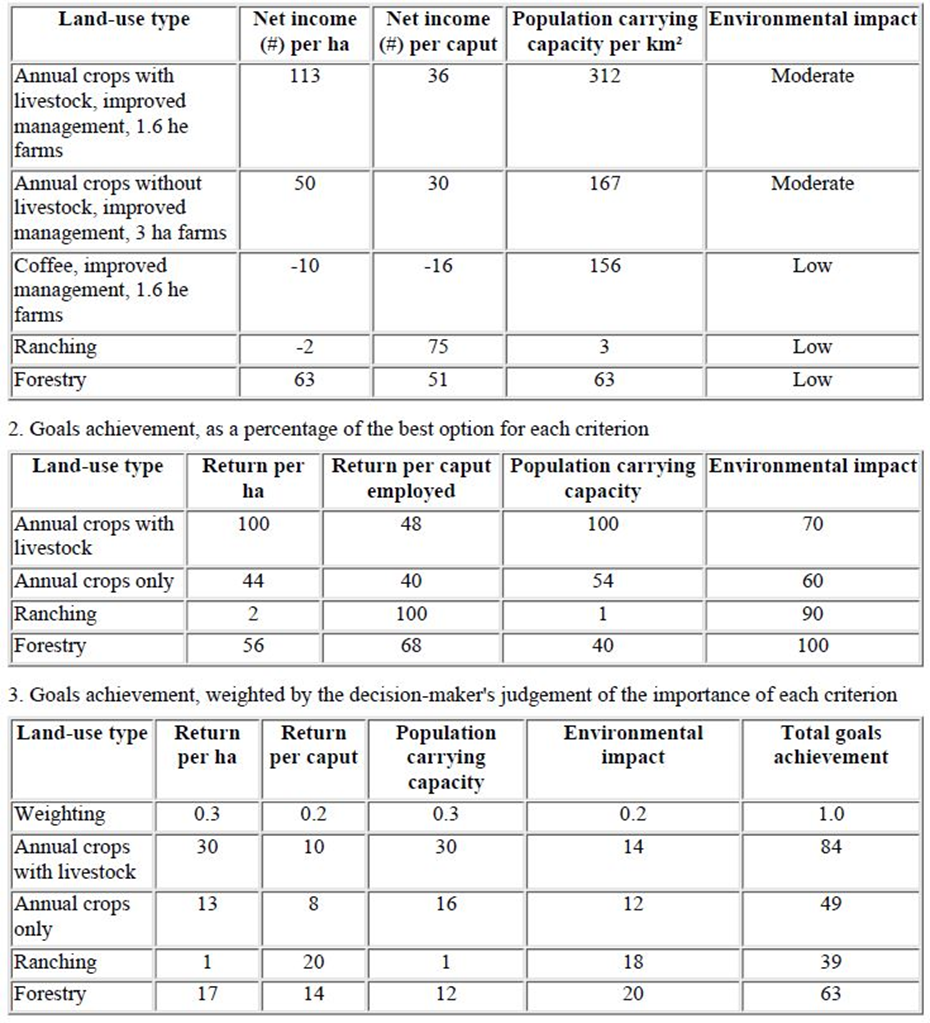
In the first table, each land use type (column 1) is evaluated against selected criteria relevant to the area (columns 2–5), for example:
1. Net income per hectare
2. Net income per person
3. Population carrying capacity
4. Environmental impact
In the second table, these objective indicators are converted into a GAM by assigning numerical scores on a common percentage scale, indicating how well each land use type meets each criterion.
In the third table, the GAM is further refined by applying weights that reflect the importance of each criterion.
Despite the subjectivity involved in assigning weights, the goals achievement matrix is a valuable tool. It summarizes results from various analyses, provides an entry point for adjusting land use policy priorities, and offers a solid foundation for stakeholder negotiations in Step 6.
An alternative method for comparing development options is to assess their capacity to deliver essential ecosystem goods and services. These can be linked to six tangible components (Nachtergaele et al., 2010):
• Biomass production and increments (vegetation)
• Soil health
• Water quality and quantity
• Biodiversity
• Economic value
• Social services
These components and their ratings can be visualized using radar diagrams, with values plotted on a common scale from 0 to 100, similar to the GAM approach.
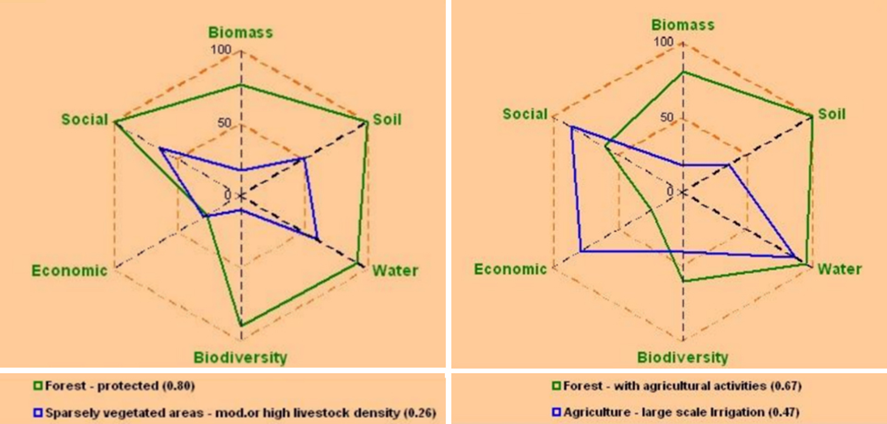
Figure 29 provides an example of how radar diagrams can be used to visualize the perceived performance of different land use systems in delivering key ecosystem goods and services. The shorthand labels used in these diagrams represent specific goods and services, which are listed in Table 9. As with the Goals Achievement Matrix (GAM) approach, weights can be assigned to each criterion to reflect their relative importance.
Table 9. List of ecosystem goods and services
(modified after Ehrlich and Ehrlich, 1991; Lubchenco et al., 1993 and Richardson, 1994)
| Ecosystem goods | Shorthand in radar diagrams |
| Food | Economic/ Biomass/ Social |
| Construction materials | Economic |
| Medicinal plants | Economic/ Biodiversity |
| Wild genes for domestic plants and animals | Biodiversity |
| Water | Water/ Economic |
| Ecosystem services | |
| Maintaining hydrological cycles | Water |
| Regulating climate | Water/ Soil/ Biomass |
| Cleansing air and water | Water |
| Maintaining the gaseous composition of the atmosphere | Biomass |
| Pollinating crops and other important plants | Biodiversity |
| Generating and maintaining soils | Soil |
| Storing and cycling essential nutrients | Soil |
| Absorbing and detoxifying pollutants | Soil |
| Providing beauty, inspiration and recreation | Social |