
Implementing Integrated Land Use Planning: A step-by-step guide for rural areas
INTRODUCTORY GUIDE: CHAPTER 1. NATURE AND SCOPE
1.2. LAND USE PLANNING
1.2.2. Integrated land use planning
In contrast to traditional land use planning, Integrated Land Use Planning (ILUP) accounts for the diverse interests in land that are increasingly recognized as essential not only for achieving environmental goals but also for addressing socio-economic and cultural considerations (Verburg et al., 2022).
This approach to “integration” is captured by the following definition (Metternicht, 2018):
Integrated Land Use Planning involves the assessment and allocation of land-based resources across a landscape, taking into account varying uses and demands from different stakeholders.
ILUP seeks to integrate environmental, socio-cultural, and economic data from a range of stakeholders to allocate land in the most optimal manner according to its suitability. It also takes into account differing stakeholder preferences and integrates legal frameworks, operating at the levels of policy, regulation, and zoning (Verburg et al., 2022).
The focus on stakeholder interests in ILUP distinguishes it from the top-down approach to land use planning, as outlined in the FAO’s 1993 guidelines, which relied heavily on physical and economic land evaluation to determine land allocation.
Like the FAO guidelines, ILUP still emphasizes agriculture and natural resource management but also considers the growing trend of urbanization in previously rural areas and its impact on agriculture and other land uses.
ILUP aims to identify the combination of land uses in a given landscape that best meets stakeholder needs while safeguarding resources for future generations. By considering all land uses in an integrated manner, ILUP identifies the most efficient trade-offs between options, linking social and economic development with environmental protection. This helps achieve sustainable land management (FAO, 2018).
Given its broad scope, ILUP faces significant challenges in most countries. Key considerations include:
- Governance structure: the structure of the national government (e.g., federal, centralized, or regionalized unitary), the level of interaction between planning at various levels (national, sub-national, local), and the country’s legal framework determine the legal scope of land use planning.
- State-market interactions: the balance between market forces and state interventions, which varies by country and may evolve, sets the political-economic context for land use planning.
- Land tenure: land use planning must be responsive to different forms of tenure (private, communal, state property, or mixed systems) that may coexist within a country.
- Level of obligation: countries differ in the enforceability of land use plans, with some being legally or contractually binding while others rely on voluntary compliance.
- Level of integration: land use planning systems differ in how well they integrate institutions and plans both vertically (across levels of governance) and horizontally (across sectors).
- Scope and focus: land use planning can vary from a narrow focus on issues like zoning to a broader, comprehensive approach that incorporates societal, economic, and environmental goals (e.g., “greening society”).
- Stakeholder participation: while participation is a formal part of most land use planning systems, the level of citizen involvement can range from tokenism to active control.
- Decision-making/planning units: land use plans may be developed at a different governance level than where they are implemented. Some systems allow for spatial planning units to follow biophysical boundaries, such as watersheds or landscapes.
- Policy instruments: countries use a variety of policy instruments to implement land use goals at different spatial scales, including national guidelines, land use zoning, location-specific plans, and market-based, regulatory, or voluntary agreements.
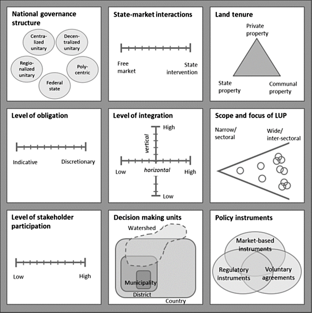
These nine key elements of ILUP are summarized in Figure 3. The nearly limitless combinations of these elements lead current guidelines to focus on “typical” planning environments characterized by the following:
• Governance structures that allow interaction between different levels of planning.
• A market economy, with varying levels of state intervention.
• An existing land tenure system that is considered as is, not as it should be.
• Legally or contractually binding land use plans agreed upon by all stakeholders.
• Vertical and horizontal coordination among government structures and agencies.
• A focus on land use planning for rural development, excluding urban and infrastructure planning.
• Active stakeholder participation.
• Responsibility for planning, implementation, and evaluation may lie with different entities.
• Consideration of all policy instruments (legal, market-based, voluntary).
Box 1. Summary: Integrated Land Use Planning
- ILUP is a process that aims to enhance the sustainability of land use and management through full stakeholder participation.
- It assesses the biophysical, socio-economic, and legal conditions of a landscape, drawing on both multidisciplinary and local expertise to optimize land use across the landscape.
- ILUP is an approach to planning, not a science or a set of universally applicable procedures. Each planning situation is unique and requires specific solutions.
- The ILUP approach is participatory, multidisciplinary, step-by-step, and iterative.
- ILUP results in a “territorial pact” that is negotiated, implemented, evaluated, and monitored.
- The meaning of land use planning varies depending on the planning level.
- ILUP differs from traditional land use planning in that it:
- Focuses on the integration of diverse stakeholder interests and aims to optimize land use across a landscape, rather than solely organizing physical space (e.g., determining land use for housing, agriculture, forestry).
- Involves a participatory, bottom-up approach, with active stakeholder engagement in both the development and implementation of land use plans, contrasting with traditional, top-down methods often developed and implemented by central authorities with minimal stakeholder involvement.