
Implementing Integrated Land Use Planning: A step-by-step guide for rural areas
PRACTITIONER’S GUIDE: STEP 4
PART 3
4.1.4. Task Force and data needs at local level
As noted in Step 3, the Task Force at local level is typically composed of local people with strong knowledge of the land and land users, and who are recognized as such by the community. They are supported by technical experts capable of conducting specialized studies—such as mapping biophysical features or carrying out sociological surveys—to facilitate participatory village-level land use planning. At this level, the role of the extension officer is crucial. Financing often comes from higher levels (district or national), which typically have a representative in the local Task Force.
For these situations, cost-effective methods of participatory village-level land use planning have been developed. These methods usually involve support from higher levels, such as temporary expert visits and capacity-building efforts to strengthen local ownership. These approaches are part of the Participatory Rural Appraisal (PRA) toolkit (Box 10), further summarized in Annex 2.
Of particular relevance for Step 4 at the local level are PRA approaches to mapping and stakeholder analysis.
Box 10. Participatory Rural Appraisal (Chambers, 1994)
Described by Chambers as “a growing family of approaches and methods to enable local people to share, enhance and analyze their knowledge of life and conditions, to plan and to act,” PRA has its origins in activist participatory research, agroecosystem analysis, applied anthropology, field research on farming systems, and Rapid Rural Appraisal (RRA).
The key difference between RRA and PRA is that in RRA, information is elicited and processed by outsiders, whereas in PRA it is shared and owned by local people.
PRA methods include:
• Mapping and modeling
• Transect walks
• Matrix scoring
• Seasonal calendars
• Trend and change analysis
• Well-being and wealth ranking and grouping
• Analytical diagramming
PRA applications span natural resource management, agriculture, poverty and social programs, health, and food security.
The full spectrum of PRA methods is summarized in Annex 2.
4.1.4.1. Participatory mapping
Participatory mapping involves transect walks or two-dimensional mapping, led by local people.
A transect map is produced during a walk across a transect of a village or landscape. In rural planning, its main purpose is to gain an understanding of the local agro-ecosystem.
These walks are conducted by a group of knowledgeable community members along paths that cross significant biophysical transitions—such as changes in slope, soil type, land use, or management—and areas with different problems or requiring different interventions.
The transect group should ideally be diverse in knowledge, experience, and opinions, and can be assisted by outsiders with specific technical expertise (e.g., a soil scientist).
Transects conducted by different community groups—such as men vs. women or elders vs. youth—may result in different maps, providing complementary insights based on each group’s specific perspectives (Fig. 14).
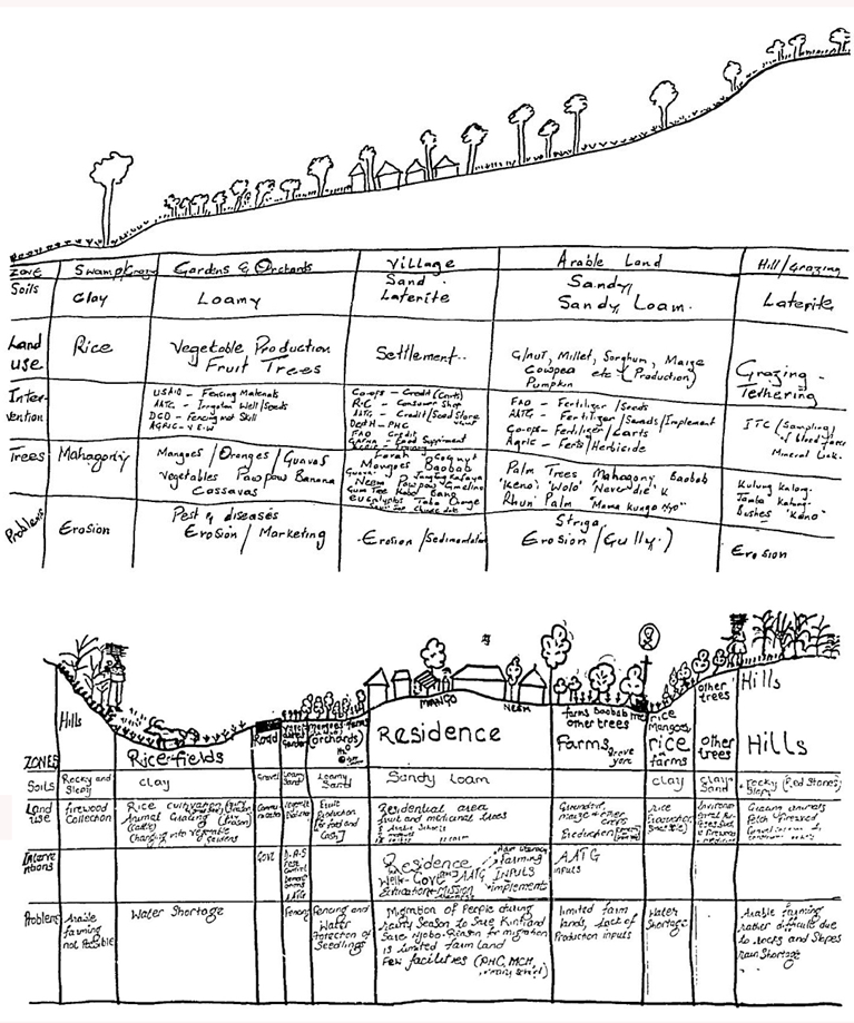
This method, combining key informants and transect mapping, is particularly useful for evaluating -from the land user’s perspective – the suitability of different areas for improved land use options or management interventions. The approach is adaptable to a wide range of physical, cultural, and development settings. However, care must be taken to ensure that selected transects are representative of the local agro-ecosystem and reflect community consensus.
The exact location of transects and main observation points can be recorded using GPS, aligned with satellite imagery, and eventually incorporated into a centralized GIS system. Transect walks thus supplement formal mapping procedures and are an excellent tool for capturing the diversity of local environments.
A natural extension of the transect map is the participatory two-dimensional map. An example is shown in Figure 15 for the same village in The Gambia. These village sketch maps help reveal social issues, including aspects related to wealth/poverty, land tenure, and infrastructural or cultural resources.
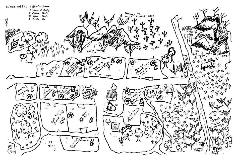
Sketches of landscape and village features drawn by local people, as in Figures 14 and 15, can provide valuable information, but they have limitations. The main drawback is that these sketches are not to scale and cannot be directly transferred onto accurate maps.
However, when a geo-referenced satellite image is made available to the community, accurate participatory mapping becomes feasible (Box 11).
Box 11. The role of satellite imagery in participatory mapping
With the recent near-universal availability of high-resolution imagery through platforms like Google Earth, it has become possible to observe terrain features in great detail. This includes detailed patterns of natural vegetation, land use, human settlements, roads and tracks, land surface colors, and even burning patterns. Knowing the date of the imagery is essential to understand which season or crop calendar period the images represent.
Experience shows that, with the guidance of trained facilitators, villagers can quickly learn to mark features of interest on such images (Fig. 16).
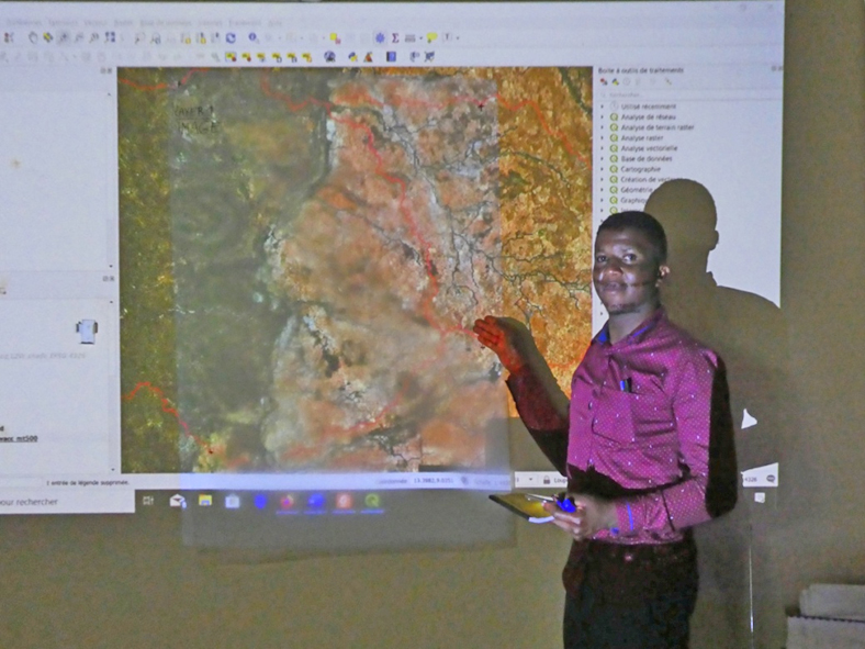
The approach can be summarized as follows:
1) In the back-office:
• Use Google Earth (GE) to zoom into the local area of interest.
• Mark the four corner points of this area using the GE marker tool and note their coordinates.
• Save the image at the highest resolution and print it in a large format (e.g., A1 or A0), preferably on poster paper or durable material such as polyester film.
2) In the field:
• Place a transparent sheet over the satellite image print and transfer the corner markings from the image to the sheet.
• Let local people, with some initial guidance, take the lead in identifying landscape features and resources[*].
• Use probing questions and appropriate PRA techniques to elicit detailed information.
• Photograph the transparencies with the mapped features and corner points.
3) Back in the office:
• Digitize the recorded local features using a GIS, guided by the photos of the mapped transparencies.
Detailed guidelines for this participatory mapping method can be found in National Land Use Planning Commission (2018) and Willemen et al. (2014).
The main benefits of this method include acceptable cartographic accuracy and cost-effectiveness, as it reduces the need for paid fieldwork personnel, especially in remote or inaccessible terrain, while leveraging the local knowledge within communities. The drawback is the need for a central GIS facility with skilled personnel to process the data.
NOTE: A good example of the use of satellite imagery in participatory land use mapping in Tanzania is provided in this video: https://www.youtube.com/watch?v=gf_3RpFAtyE
4.1.4.2. Village boundary delineation
Conflicts between neighboring villages can arise in countries where village or town boundaries are not fixed by law and not registered in official documents or maps. The issue of overlapping boundaries is often acute where there are frictions between traditional (unwritten) land laws and gazetted government legislation, especially in contexts involving forest conservation or other regulated land uses.
When boundaries are unclear, interventions focused on one village—such as fencing to restrict overgrazing—may inadvertently affect neighboring communities, for example by reducing access to common grazing lands. In such cases, participatory mapping becomes a valuable tool for the resolution of boundary disputes.
In areas where boundaries are not properly registered, it is important to obtain consensus among concerned villages, even if no current dispute exists. The process may involve:
• Preparing a sketch map of the village, including key landmarks and topographic features.
• Where feasible, organizing a participatory walk with representatives from the concerned villages (e.g., village council members, elders), assisted by a Task Force member for mediation and GPS readings.
• Transferring coordinates of the track or reference points onto a satellite image print, Google Earth, or a central GIS.
The preferred method of resolving boundary disputes is through mediation between the directly involved parties, rather than formal court arbitration. Once an agreement is reached, a written record should be prepared and signed by the involved village authorities. The Task Force can assist in drafting this document.
4.1.4.3.Stakeholder analysis
The initial work in Step 2 by the Coordinating Unit likely resulted in a preliminary identification of key internal and external stakeholder categories, along with insights into whether their interactions are cooperative, competitive, or conflictual.Step 4 provides the opportunity for a more in-depth characterization of stakeholders. Effective local-level land use planning requires a thorough understanding of the various stakeholders within and interacting with the community, especially regarding socio-economic status, power dynamics, wealth and poverty, and gender balance.
A range of participatory tools are available to assist in this analysis, including:
• Stakeholder Matrix
• Livelihood analysis
• Well-being and wealth grouping and ranking
• Access to and control of resources
• Decision-making matrix
These tools are explained with worked examples in FAO (2011b).
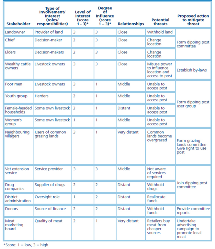
The Stakeholder Matrix method offers a clear illustration of how such tools can be applied during stakeholder meetings. It is a table used to analyze each stakeholder group against criteria relevant to the specific land use planning initiative. It helps determine which stakeholders have high or low stakes in the plan, and which have high or low influence over its implementation.
Box 12 provides an example of this approach, using the hypothetical Venn diagram from Box 7 as a starting point.
Box 12. Using the Stakeholder Matrix in a stakeholder meeting (FAO, 2011b)
1. Prepare a matrix on a flip chart (see Figure 17) to deepen understanding of the various players and their positions.
2. List the main stakeholders (people and institutions) potentially relevant to the development intervention in the left-hand column. Include all that are important.
3. Discuss the matrix topic headings and sequentially fill in the first five columns for each stakeholder:
• services and assistance provided
• interests in the activities
• potential influence in the activities
• relationships with other stakeholders
• potential threats
The results from stakeholder meetings should be validated through interviews with a cross-section of land users, relevant government officials, local authorities, and key informants.