

2.1.4.4. The ICARDA Agro-Climate Tool
The ICARDA Agro-Climate Tool (I-ACT) is a GIS-based software tool specifically developed to estimate in each part of the ICARDA mandate region the severity of climatic stresses, including drought, wetness, heat and cold. The software is a stand-alone Visual Basic application that runs under all versions of Windows, from Windows 98 up to the current version. Processor and hard disk space requirements are modest by current PC standards.
I-ACT was developed under a collaboration agreement between the USDA-ARS Plant Stress and Water Conservation Lab, Texas and ICARDA, with Steve Mauget and Eddy De Pauw as principal investigators. The work hypothesis in the development of I-ACT was that it would be possible to provide realistic assessments of drought, cold and heat risks by (1) using for stations with insufficient historical data, synthetic climatic data, created by stochastic weather generator software, and (2) extrapolating this information from stations to areas.
More info on stochastic weather generators
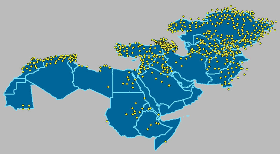
The I-ACT project was at the same time highly challenging and innovative. The main challenge was to deal with the low density and unequal distribution of meteorological stations with sufficiently long records in the CWANA region (see Figure 2).
The innovation of I-ACT is in the way different databases, statistical procedures, programming tools and visualization methods were integrated into a single stand-alone application in order to assess climatic stresses in a data-scarce region.
It involved:
• Use of global daily temperature and precipitation databases;
• Establishing parameter statistics of time series;
• First-order Markov chain analysis to separate dry and rainy days;
• Fitting to a frequency distribution to assign rainfall amounts to rainy days;
• Modified use of a stochastic weather generator to provide ‘synthetic’ precipitation and temperature data;
• Fourier analysis for separating genuine climatic signals from noise, data compression and storage;
• Derivation of secondary variables (potential evapotranspiration, crop water requirements and water stresses);
• Spatial interpolation of weather generator output to areas between stations, with a built-in temperature correction through a global digital elevation model (GTOPO30);
• Embedding all climatic databases and GIS layers inside the application;
• Dashboard design allowing visualization and export of outputs for either user-selectable periods or crop growth periods.
Evaluation and outlook
- The weather generator’s performance, evaluated in terms of how well the generated primary data of precipitation and temperature correspond with real values, is very good. However, the smoothing processes involved in using only a few Fourier harmonics and randomization tend to underestimate the real variability. This issue can be addressed technically: I-ACT was designed for what is nowadays considered modest computer power. Current PC processors, such as Inter Core i7, have vastly more power and can accommodate larger databases, allowing incorporation of more Fourier harmonics.
- The weather generator is unable to compensate for the many gaps in meteorological observations in the CWANA region. These are responsible for significant sampling errors in the weather generator statistics. The latter can be reduced by generating new weather generator parameters based on a longer time series.
- Above considerations suggest optimal development and use of I-ACT style applications is not at regional but at national level. National meteorological organizations have in many instances a number of representative long-term meteorological records that can be used for local calibration of a weather generator and combined with appropriate crop data and GIS layers.
- As a concluding statement it could be argued that the potential impact of applications like I-ACT in terms of assessing climatic stresses, both under current or future climates, has been insufficiently recognized. This could be due to its publication in a meteorological journal, which few agriculturalists read, and its limited Internet distribution. Hopefully publication through this website may increase recognition of its potential uses.
NOTE:
The following information sources provide all necessary files and documentation for using the ICARDA Agroclimate Tool:
Software download / Journal article / Technical description / User guide / Summary lecture