
Implementing Integrated Land Use Planning: A step-by-step guide for rural areas
PRACTITIONER’S GUIDE: STEP 5
PART 2
5.1.1. Biophysical land suitability
Land suitability is assessed through land evaluation procedures, which aim to answer two key questions:
1) Which land units are suited for a specified type of land use?
2) What land uses are suitable for a given land unit?
Land is primarily defined by its biophysical characteristics—climate, vegetation, water and soil resources, and topography—which are location-specific. However, different management options and input levels can be considered within the evaluation.
Land evaluation procedures have their roots in the Framework for Land Evaluation (FAO, 1976). The core principles of this framework (→ Box 14) have remained largely unchanged and have since been expanded in guidelines for major agricultural land uses (e.g., FAO, 1984a; 1984b; 1985; 1991). These principles have been adapted to incorporate new technologies and participatory approaches (FAO, 2007), are taught in numerous courses and textbooks (e.g., Dent, 1981; Rossiter, 1994; Sys et al., 1991; Verdoodt and Van Ranst, 2013), and are embedded in software tools such as ALES and AEZ. The scientific literature contains thousands of case studies applying these principles to specific contexts.
Box 14. Principles of land suitability evaluation
The 1976 FAO Framework for Land Evaluation established the following key principles:
- Land suitability should be evaluated for specific types of land use.
- Evaluation requires a comparison of the benefits gained and the inputs needed across different land types.
- The evaluation process should be multidisciplinary, involving various technical fields.
- Land evaluation must consider biophysical, economic, social, and political contexts, along with environmental concerns.
- Suitability refers to use on a sustained basis, ensuring long-term viability.
- Evaluation involves comparison among multiple types of land use.
At its core, land suitability evaluation involves matching the characteristics of land units with the requirements of a land use system or utilization type. Biophysical requirements for hundreds of crops and land use types are available from databases such as ECOCROP (FAO, 1998) and GAEZ (Fischer et al., 2021).
The degree to which a land unit meets the requirements of a land use can be assessed using performance scores, which may be qualitative or quantitative. A commonly used qualitative scoring system is the land suitability classification (FAO, 1976):
- Highly suitable (S1): Land with no significant limitations for a specified sustained use. Productivity or benefits are not reduced, and input needs remain within acceptable limits.
- Moderately suitable (S2): Land with moderate limitations. Productivity or benefits are somewhat reduced, and input needs are higher, resulting in appreciably lower advantages compared to S1 land.
- Marginally suitable (S3): Land with severe limitations. Productivity or benefits are greatly reduced, and the required input levels barely justify the land use.
- Not suitable (N), often divided into:
- Currently not suitable (N1): Land with limitations that might be overcome in time, but not at currently acceptable costs.
- Permanently not suitable (N2): Land with limitations so severe that sustained use is not feasible under any foreseeable conditions.
The matching process used in land evaluation can range from simple to highly complex:
• At its simplest, matching is based on empirical knowledge. For example, farmers may predict yields on similar soils based on past experience, using a holistic approach that evaluates the land as a whole rather than by individual properties.
• In a more detailed approach, used by land use planners, soil scientists, and other specialists, measurable land characteristics (e.g., slope, rainfall, soil texture, depth, pH, salinity) are analyzed for their influence on the performance of a land use system.
To resolve the interactions between characteristics, practitioners often use land qualities instead of individual characteristics. Land qualities are integrated land attributes directly linked to suitability for specific uses, such as:
• Moisture availability
• Erosion hazard
• Nutrient availability
• Soil workability
• Soil toxicity
Only the relevant land characteristics or land qualities are considered for a given evaluation.
Once assessed, land characteristics or qualities are assigned class or numerical scores. These scores are then integrated into an overall suitability evaluation using methods such as:
• The most limiting factor approach, where the lowest score determines suitability.
• A weighted scoring system, combining limitations into a composite suitability score.
The evaluation procedure can be repeated for different land uses, management systems, and input levels, and the resulting suitability classes can be mapped using GIS tools.
From early on, there was recognition that the narrow biophysical focus of traditional land evaluation needed to be broadened. The current understanding (FAO, 2007) is that land evaluation should not only address productive potential, but also assess the state and trends of environmental services and sustainable livelihoods, placing greater emphasis than the original framework on participatory methods and multidisciplinary approaches.
In line with these expanded principles, land suitability evaluation today must be part of a participatory, multidisciplinary process that also includes economic, environmental, social, and legal analyses—each with its own methodologies and procedures.
Within its original scope—the assessment of biophysical potential—land suitability evaluation is relatively scale-independent: its principles can be applied from the global to the local level. However, the way in which the evaluation is implemented depends on:
• the detail and accuracy of available data;
• and whether the planning objective requires a qualitative assessment or quantitative results.
5.1.1.1. Qualitative land evaluation
In general, a suitability evaluation can be expressed in qualitative terms using the suitability classes defined in Box 14 (see example in Table 6).
Table 6. Example of a land evaluation table using suitability classes (modified from FAO/UNEP, 1999)
| Land suitability unit | Crop and input level | |||||||
| Maize | Wheat | Barley | Teff | |||||
| Low | Intermed. | Low | Intermed. | Low | Intermed. | Low | Intermed. | |
| A | N | N | N, S3 | S3,n | N, S3 | S3,n | N, S3 | S3,n |
| B | S3,N | S3,n | S1,N | S1,n | S1,N | S1,n | S2,N | S1,N |
| C | S3,n | S2,n | S1,N | S1,n | S1,N | S1,n | S3,N | S3,N |
| D | N | N | S3,N | S3,n | S2,s3,n | S2,S3 | N,s3 | N,s3 |
| E | N | N | N | N | S3,N | S3,N | S3,n | S3,n |
NOTES:
1. Land suitability units are derived from combinations of soil mapping units, rainfall and altitude.
2. ‘Intermediate’ level of inputs includes implementation surface drainage by broadbeds and furrows.
3. S1 = highly suitable, S2 = moderately suitable, S3 = marginally suitable, N = not suitable.
4. Where more than one suitability class is indicated, the suitability of the unit varies according to different soil types, which are not mappable at the scale used (1:250,000).
An uppercase designation implies that 50% or more of the unit is in the indicated class, a lowercase designation that 25% of the unit is in the designated class, e.g. S3,N: 50% S3, 50% N; S3,n: 75% S3, 25% n; S2,s3,n: 50% S2, 25% s3, 25% n.
This method has the advantage of a certain ‘fuzziness’, allowing the evaluator flexibility in reaching a conclusion, which aligns with the way farmers typically assess their land. Additionally, suitability classes can be further specified based on the type and severity of limitations for the land utilization type (LUT) under consideration. For example, S2e might indicate moderately suitable land where the primary limitation is erosion hazard.
To express the degree of matching more precisely, numerical scores can also be used—typically on a 0–100 scale—even though these are still considered qualitative ratings. Such scoring allows for finer distinctions between land units and can help prioritize interventions or compare alternative uses more effectively.
An example of this approach is provided in Box 15, illustrating the evaluation of water harvesting technologies using a numerical scoring system.
Box 15. Land suitability for water harvesting
Water harvesting encompasses a range of techniques designed to collect rainwater from natural or modified surfaces and concentrate it for use on smaller target areas, such as cultivated fields, to ensure economic crop yields. The collected runoff may be stored in the soil’s root zone, behind dams or terraces, in cisterns, gullies, or used to recharge aquifers.
Water harvesting systems vary in design, but they share three core components:
1. A catchment or source area,
2. A storage facility, and
3. A target or use area.
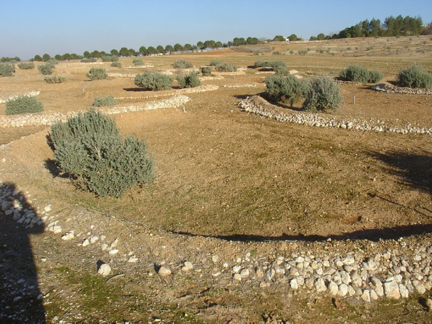
In micro-catchment systems, the source and target areas are so closely located that they cannot be separated beyond the field scale (see Figure 19).
In a GIS context, this proximity means the source and target areas occupy the same pixel, typically of small size (e.g., 100–250 m). The storage facility in such systems is often the soil’s root zone for immediate use, or a small reservoir for short-term storage.
In contrast, macro-catchment systems collect runoff from a larger catchment area situated outside the smaller target area. Storage is provided by:
• Surface structures (e.g., small farm reservoirs),
• Subsurface structures (e.g., cisterns), or
• Soil storage within the source and target areas, which are located in different pixels.
In this study, a rapid GIS-based land suitability assessment was conducted to evaluate the potential for various micro- and macro-catchment water harvesting systems in Syria. The evaluation involved matching simple biophysical data, available at the national level, to the general requirements of different water harvesting systems using an expert-based empirical decision model.
A total of 13 micro-catchment systems were assessed, based on combinations of six techniques and three crop groups, along with one generalized macro-catchment system. Figure 20 presents a map of suitability scores for one of the evaluated systems.
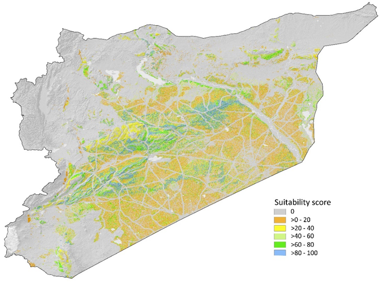
The environmental suitability criteria were adapted from the guidelines by Oweis et al. (2001) for selecting water harvesting techniques in dryland environments. Criteria included precipitation, slope, soil depth, texture, salinity, land use/land cover, and geological substratum.
The evaluation was conducted in two stages:
• Scoring individual land attributes based on the criteria, and
• Combining the scores in a multi-criteria evaluation.
For continuous variables like precipitation and slope, fuzzy membership functions were applied to determine suitability.
For detailed methodology, see De Pauw et al. (2008).
5.1.1.2. Semi-quantitative land suitability assessment
Land suitability can also be assessed using true quantitative scores: these express a direct relationship with measurable variables, such as crop yields or other factors linked to financial or economic benefits.
Applications of Agro-ecological Zoning (AEZ) aim to produce quantitative estimates of potential and attainable crop yields by modeling the interactions between climatic and agro-edaphic conditions and specific land utilization types (LUTs). This approach, primarily designed for use at global, regional, or national planning levels, is detailed in Box 16.
Economic land evaluation, appropriate for farm-level assessments of economic viability or profitability, is discussed in Section 5.1.3.
Box 16. Land suitability assessment using the Agro-ecological Zoning (AEZ) methodology
Agro-ecological Zoning (AEZ) is both a spatial database of the Earth’s biophysical resources and a methodology for matching these resources with hundreds of land use types. Developed over the past 30 years by FAO and the International Institute for Applied Systems Analysis (IIASA), AEZ is a unique example of multi-thematic data integration and the use of advanced modeling approaches within a GIS-based environment to support land use planning.
AEZ determines land suitability by providing quantitative estimates of biomass production and crop yields through the integration of climatic, soil, topographic, land use, and statistical data. These estimates are generated:
• Globally, for individual grid cells of 5 arc-minutes (approximately 9 × 9 km at the equator), and
• Nationally, for many countries at higher resolutions.
The methodology is based on the combination of two core models:
1. The climatic growing period, and
2. Potential biomass productivity.
Climatic growing period
In many regions, moisture and temperature are key constraints on biomass productivity. The climatic growing period model identifies the time(s) of year when conditions for vegetative growth and biomass production are optimal. The model, used by GAEZ, evaluates, on a daily basis, soil moisture and temperature conditions throughout the year.
• Soil moisture availability is assessed using a generalized water balance approach that considers precipitation, soil moisture storage capacity, evapotranspiration, deep percolation, and runoff losses.
• Temperature adequacy is determined based on model-defined temperature thresholds, below which no growth is possible.
Potential biomass productivity
In GAEZ, potential biomass productivity is estimated using a simplified crop growth simulation model (based on de Wit, 1965), where constraint-free biomass production is driven solely by the crop’s photosynthetic pathway, and the local radiation and temperature regime. Potential yield is then derived by applying an appropriate crop- or variety-specific harvest index.
The AEZ model incorporates the following climate and crop characteristics in calculating constraint-free biomass and yield:
• Heat and radiation regime over the crop cycle,
• Crop adaptability group (C3, C4, or CAM) to define the rate of photosynthesis,
• Length of the growth cycle (from emergence to physiological maturity),
• Length of the yield formation period,
• Leaf area index at maximum growth rate, and
• Harvest index (Fischer et al., 2021).
Land suitability evaluation using AEZ
Given its foundation in crop growth simulation, AEZ emphasizes land suitability for crop production. In line with the core principles of land suitability evaluation, AEZ matches land unit characteristics with the requirements of the considered LUT, evaluating the match in either:
• Qualitative terms (suitability classes), or
• Quantitative terms (kg/ha).
The matching process assesses the constraints imposed by climate, soils, and other factors on the modeled constraint-free biomass production and yield.
AEZ estimates yield reductions due to the following constraints:
1) Agro-climatic constraints:
Impacts from climate such as mismatch between crop growth cycle and growing period, water stress, pests and diseases, unfavorable working conditions, and frost hazard.
2) Agro-edaphic constraints:
Impacts from soil and terrain-slope conditions.
Soil suitability is evaluated through the following land qualities:
• Soil nutrient availability,
• Soil nutrient retention capacity,
• Soil rooting conditions,
• Soil oxygen availability for roots,
• Presence of salinity and sodicity,
• Presence of lime and gypsum, and
• Soil workability.
Terrain-slope suitability is evaluated for its potential impact on soil erosion and fertility loss. Each soil–terrain–slope combination is rated individually.
Estimated yield losses from agro-climatic and agro-edaphic constraints (expressed as percentages) are modeled for each LUT under generalized management systems, defined by input levels (low, intermediate, high) and four types of water supply (rainfed, gravity, sprinkler, or drip irrigation).
The final step is deducting these quantified yield losses from the constraint-free potential yields, resulting in site-specific attainable yields.
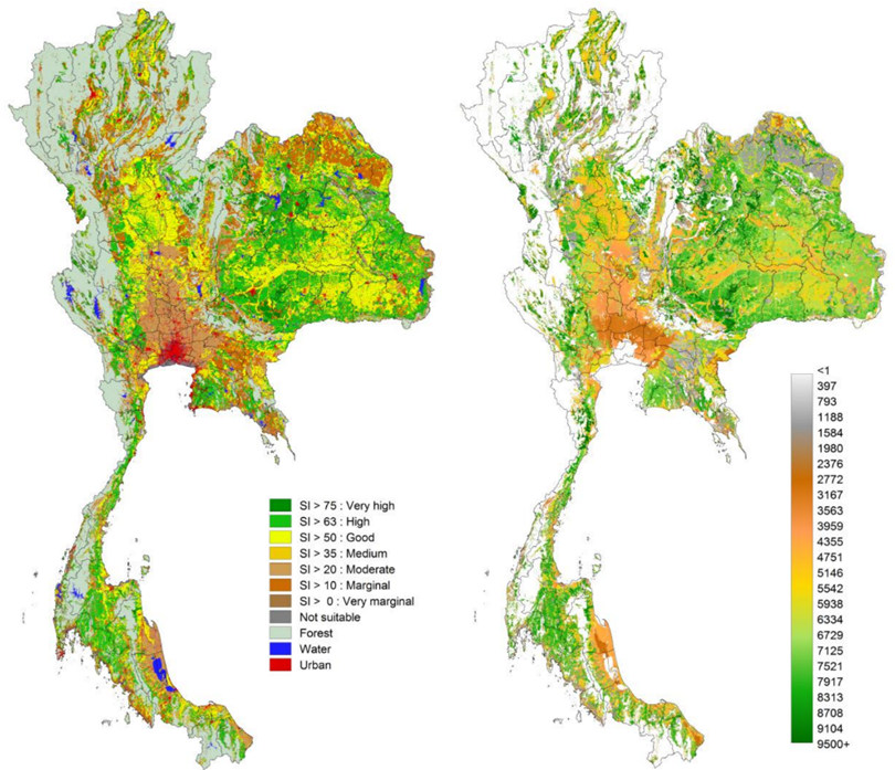
Figure 21 provides a national example of land suitability for cassava in Thailand (FAO, 2017).
5.1.1.3. Quantitative crop simulation models
Crop models simulate how crops grow in interaction with their environment. These models are mathematical algorithms that utilize quantitative data from agronomic research to explain and predict crop growth and development with high accuracy (Hoogenboom et al., 2019). The best known among them are CROPSYST, DSSAT, and WOFOST. While differing in complexity, technical features, and application domains, they share the ability to simulate crop development, growth, and yield based on weather and soil data, crop cultivar characteristics, and management practices.
Such models are particularly valuable for analyzing specific crop situations under well-controlled conditions, for instance, at research stations where new crop varieties are tested. However, they are highly data demanding, requiring daily weather data—available only from a limited number of meteorological stations—and detailed reference soil profiles. As model complexity increases, outscaling and ensuring reliable performance beyond local conditions become more challenging.
For broader area assessments, simplified models such as AEZ—which aim to estimate plausible yield ranges rather than precise yields—are more suitable for land use planning, provided they are validated using national crop statistics. WOFOST offers a good compromise between data requirements and regional applicability. It is employed in the EU Crop Growth Monitoring System for operational monitoring of arable crops and for crop yield forecasting across Europe.