
Implementing Integrated Land Use Planning: A step-by-step guide for rural areas
INTRODUCTORY GUIDE: CHAPTER 1. NATURE AND SCOPE
1.4. Planning at different levels
While the planning model outlined in Figure 4 is desirable, it presents several challenges, particularly because actors within the stakeholder collective often operate at different planning levels, each with its own priorities and scales. These challenges are linked to the friction between top-down and bottom-up participatory planning.
At first glance, top-down planning and participatory planning may seem incompatible. However, they are complementary and should ideally work together in real-world situations, provided they are applied at the appropriate scale with clearly defined competencies and responsibilities. To achieve this, it is crucial to recognize the strengths and weaknesses of both approaches.
The main strength of the top-down approach is its ability to quickly set land use development goals for an entire country or region through strategic plans, legislation, and directives. Since these directives come from a central authority and ideally adhere to objective planning standards, they send a cohesive and uniform message to all levels of government. However, the weakness lies in the implementation of these plans. Successful execution requires buy-in from stakeholders.
This is where bottom-up approaches excel. By allowing initiatives to arise from within the stakeholder community and mobilizing local resources, these approaches increase stakeholder engagement and the likelihood of successful plan implementation.
However, bottom-up approaches also have their drawbacks. One key weakness is slow decision-making, as stakeholders with often divergent interests must reach a negotiated compromise. Another challenge is potential conflict with existing land use legislation. National legislation typically reflects a broad social consensus, and reconciling this with local community interests can be difficult. Furthermore, bottom-up planning struggles to address environmental issues that extend beyond local borders, such as the upstream diversion of irrigation water affecting downstream users or the location of large-scale infrastructure like airports and highways (Pissourios, 2014). While the land may be local, it may serve a broader community than the one physically occupying it.
When bottom-up land use planning has implications beyond local borders, a higher level of coordination is needed. A multi-scale approach, in which various governance levels have recognized authority for specific planning responsibilities, is the best way to balance top-down and bottom-up approaches.
1.4.1. Planning at the international level
In recent years, it has become clear that global challenges such as climate change, biodiversity loss, and land degradation have significant cross-boundary impacts. Recognizing the need for extraterritorial solutions, several global conventions have been adopted. These include the Paris Climate Accords (signed by 191 countries in 2015), the Convention on Biological Diversity (195 countries), and the Land Degradation Neutrality Principle (125 countries), all of which commit nations to prepare action plans that influence land use.
At the international level, planning focuses on developing visions, strategies, and action plans to address cross-boundary environmental issues. These plans are generally not legally binding, but in some cases, international agreements have been incorporated into national laws, enabling litigation in cases of non-compliance. For example, the 2019 climate litigation case, Urgenda v. The Netherlands Government, demonstrates how international agreements can influence national policies. While such cases are still rare, international agreements offer important incentives—including financial ones—to incorporate their insights into national strategies and action plans.
1.4.2. Planning at the national level
At the national level, land use planning focuses on fulfilling international commitments (such as adherence to signed conventions), achieving national goals, and allocating resources. In many cases, national land use planning does not directly allocate land for various uses but instead establishes priorities for district-level projects.
National land use planning typically involves:
• Land-use policy: balancing competing demands for land from sectors like food production, export crops, tourism, wildlife conservation, housing, roads, and industry.
• Stakeholder communication: informing farmer unions, extension services, and other stakeholders about changing market opportunities and expectations related to land suitability. Climate change, for example, may impact crop suitability in the short or long term.
• Coordination of sectoral agencies: facilitating cooperation between different agencies involved in land use, which may involve creating a pool of experts available on demand from various ministries.
• Legislation: addressing issues such as land tenure, forest clearance, and water rights.
National goals are complex, and policy decisions, legislation, and fiscal measures often affect large populations and vast areas. To be effective, it is essential that information is communicated at all relevant levels and that plans remain transparent.
1.4.3. Intermediate-level planning
When national priorities are established, they must be translated into local plans. The “intermediate level” (or “meso level“) refers to planning at the administrative levels between national and local levels. These may include regions, provinces, districts, or similar entities, depending on a country’s administrative structure.
This level is where planning first engages with the diversity of land and its suitability for different uses. For example, zoning—dividing land into areas for specific uses—is typically carried out at the district level. Development projects also occur at this stage. When conflicts arise between national and local interests, the district level is where these conflicts are often addressed and reconciled.
Key issues at the intermediate level include:
• Siting developments such as new settlements, forest plantations, and irrigation schemes.
• Addressing infrastructure needs like water supply, roads, and marketing facilities.
• Collaborating with stakeholders to develop management guidelines for improved land use practices.
1.4.4. Local-level planning
The local planning unit could be a village, a group of villages, a small water catchment area, or a landscape unit.
Local-level planning allows for the most direct engagement with people, utilizing local knowledge and contributions.
When planning is initiated at the intermediate level, the task of implementing land use or management changes falls to local stakeholders. Alternatively, local-level planning may be the first step, with priorities developed by the local community. At this level, the focus is on specific land areas—what should be done, when, and by whom. Successful implementation of land use plans requires the cooperation of local stakeholders. Negotiations and participatory approaches are essential to achieve optimal outcomes for all involved.
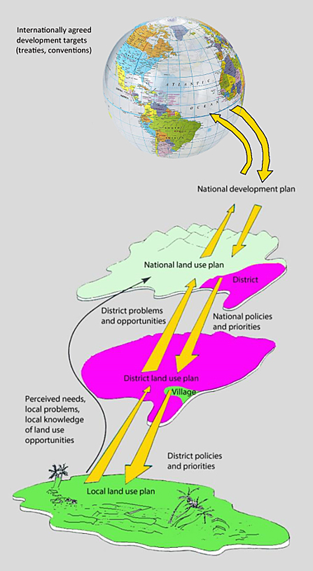
In summary, national-level planning, which deals with global, regional, or national concerns, requires a different approach than district-level planning, which focuses on managing local landscapes. Planning at the local level involves its own unique needs for implementation.
Since every planning situation is unique, the land use planning process is inherently collaborative and requires interlinked steps, feedback mechanisms, consensus-building approaches, and, when necessary, plan adaptations. Especially when different types of planning and decision-making are delegated to various administrative levels, a multi-scale approach is essential, with efficient information flow and feedback in both directions (Fig. 5).