

1.4. Tools and Approaches for Integrated Land Use Planning
Integrated land use planning combines various methods and areas of knowledge, which can sometimes feel overwhelmingly complex. However, this complexity is often more manageable than it seems. A wide range of approaches, methods, guidelines, and tools is available to help clarify the planning process and make it more accessible.
The FAO Portal “Land Resources Planning Toolbox” (LRPT) is a free online resource that serves as an excellent gateway to valuable ideas, guidelines, data, and documents for anyone involved in land use planning. The Toolbox provides summaries and links to numerous planning tools and approaches developed by the FAO and other organizations. It helps answer key questions, such as:
• What tools are available?
• What can they do—and what are their limitations?
• Which tools are most useful for specific users, regions, or levels of planning?
Searchable Attributes of the LRPT
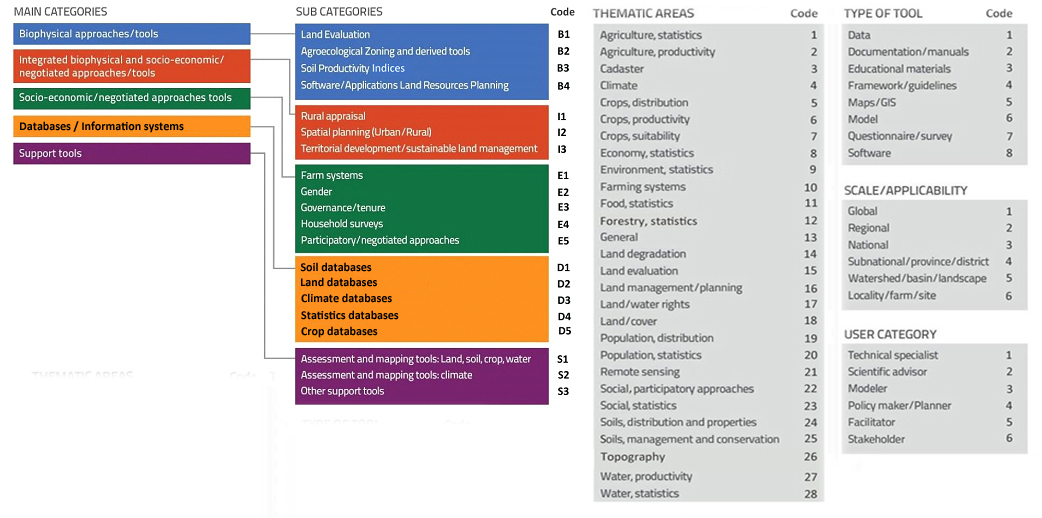
To help users effectively find and utilize tools in the LRPT, they are categorized by searchable attributes, which include main and sub-categories (Table 2) and other searchable attributes (Figure 3).
- Main and sub-categories
| B: Biophysical Approaches and Tools | This category focuses on natural features like climate, soil, terrain, and water, as well as their interactions. It includes: • Guidelines for assessing land. • Tools for categorizing soils based on their suitability for specific purposes. • Methods for understanding soil potential, limitations, and management. • Models (both simple and complex) that predict crop growth and yield based on the land’s physical and chemical properties. Sub-categories: Land evaluation / Agroecological zoning/ Soil productivity indices/ Software / Applications |
| E: Socio-Economic and Negotiation Approaches and Tools | These tools address the human aspects of land use, such as farming practices, land ownership, and community involvement in planning. They help: • Analyze social and economic factors relevant to land-use planning. • Facilitate decision-making processes in collaboration with communities. While they may consider natural features like soil and climate, the focus is not on detailed biophysical analysis. Sub-categories: Rural appraisal / Spatial planning / Territorial development / Sustainable land management |
| I: Integrated Biophysical, Socio-Economic, and Negotiation Approaches and Tools | This category merges natural and human aspects of land use, combining: • Biophysical data (e.g., soil and climate). • Social and economic conditions (e.g., community needs and economic factors). These tools often involve participatory planning, encouraging collaboration among communities and stakeholders to make informed land-use decisions. Sub-categories: Farm systems / Gender / Governance / Tenure / Household surveys / Participatory/negotiated approaches |
| D: Databases and Information Systems | These tools provide essential data for evaluating land and planning its use. Examples include: • Maps and datasets on soil, terrain, land degradation, land cover, and land use. • Climate data, including future projections. • Information on crops, yields, food, agriculture, and water resources. • Plant suitability for specific environments. • Socio-economic data, such as poverty, population, land ownership, and gender statistics. Sub-categories: Soil databases / Land databases / Climate databases / Statistics databases / Crop databases |
| S: Support Tools | Support tools supply supplementary information for land evaluation studies and provide input data for land-use decision-making. Sub-categories: Assessment and mapping tools for (1) land, soil, crop, water (2) climate / Other support tools |
2. Other searchable attributes
Users can search for tools using a built-in search engine that allows filtering by the following attributes:
Thematic Area: Tools are sorted based on their primary focus. While many tools address multiple topics, users can select one or more themes to find tools relevant to their needs.
Type of Tool: Tools are categorized by the type of resource provided, such as guidelines, datasets, or software, enabling users to choose the format that best suits their requirements.
Scale and Applicability: This attribute indicates the spatial scale at which a tool is most effective—local, regional, or global—based on its design and intended use.
User Category: Tools are identified by their target audience, such as planners, policymakers, or technical experts, helping users find resources tailored to their roles.
All searchable attributes are shown in Figure 3.
Check out this page for a List of Selected Tools for Integrated Land Use Planning